Visualizing Arrakis
Over the last few days I have been reworking parts of Rassilion's Canopus add-on for Celestia, trying to make it more faithful to the information contained in the Dune novels. The first order of business was to try to determine the size of the planet Arrakis itself.
Using the map at the beginning of Dune and some basic trig, I recalculated the radius of the planet as being 1005.0344 km...which is obviously too small. I created city locations for both Arrakeen and Carthag and fired up Celestia to check the results.

When I "landed" at Arrakeen and pulled up the information on Carthag, it showed as being about half the expected distance of 200 km. I used the value given to recalculate, plugged that in and tried again. This time the two cities were the proper distance apart. The new radius is 1996.2935 km...which is better, but still too small when you consider these:
6378.14 - Earth
6162.47 - Arrakis (Rassilion's original figure, source unknown)
6128.00 - Arrakis (Figure given in The Dune Encyclopedia)
6052.00 - Venus
3396.00 - Mars
2240.00 - Mercury
1737.53 - Luna (Earth's moon)
1151.00 - Pluto
487.500 - Ceres (Largest Solsystem asteroid)
I need to search through the books and see if there isn't something I've missed that can help clear this up. Obviously, the map has to be abandonned for this purpose. (But I plan to use it later for plotting details of the northern polar region where most of the action in the novels takes place.)
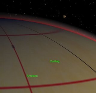
(Notes about image above: The lines on the surface of the planet show latitudes of 60 and 75 degrees N and the longitude of Arrakeen, 26W. The black line is the prime meridian, passing through Observatory Mountain. The reddish haze along the rim is an atmospheric effect. Also, you can see one of the two moons above the curve of the planet.)
Using the map at the beginning of Dune and some basic trig, I recalculated the radius of the planet as being 1005.0344 km...which is obviously too small. I created city locations for both Arrakeen and Carthag and fired up Celestia to check the results.

When I "landed" at Arrakeen and pulled up the information on Carthag, it showed as being about half the expected distance of 200 km. I used the value given to recalculate, plugged that in and tried again. This time the two cities were the proper distance apart. The new radius is 1996.2935 km...which is better, but still too small when you consider these:
6378.14 - Earth
6162.47 - Arrakis (Rassilion's original figure, source unknown)
6128.00 - Arrakis (Figure given in The Dune Encyclopedia)
6052.00 - Venus
3396.00 - Mars
2240.00 - Mercury
1737.53 - Luna (Earth's moon)
1151.00 - Pluto
487.500 - Ceres (Largest Solsystem asteroid)
I need to search through the books and see if there isn't something I've missed that can help clear this up. Obviously, the map has to be abandonned for this purpose. (But I plan to use it later for plotting details of the northern polar region where most of the action in the novels takes place.)
(Notes about image above: The lines on the surface of the planet show latitudes of 60 and 75 degrees N and the longitude of Arrakeen, 26W. The black line is the prime meridian, passing through Observatory Mountain. The reddish haze along the rim is an atmospheric effect. Also, you can see one of the two moons above the curve of the planet.)


3 Comments:
I like where you're going here chigger.
We aims to please!
Of course, the motivation isn't really to please anyone but myself. But I thought other people might be interested. It's encouraging that at least a few are.
Will keep you posted!
Where can I find your addobs for Dune on Celestia?
Post a Comment
<< Home